ASSESSMENT OF AQUIFER SUITABILITY FOR ARTIFICIAL RECHARGE: THE CASE OF THE ZIZ AQUIFER IN SOUTH-EAST MOROCCO
Journal: Water Conservation and Management (WCM)
Author: Aziza Lamchaimech, Mustapha Elbahraoui, Youssef Hahou, Ghizlane Fattah, Said Ettazarini, Moulay Ahmed Ben Driss, Mohamed El Amrani, Larbi Boudad, Najat Qisse, Jamal Mabrouki, Said Courba, Zineb Aafir, Ousaid Lahcen, Abdelhadi Ifliliss
Print ISSN : 2523-5664
Online ISSN : 2523-5672
This is an open access article distributed under the Creative Commons Attribution License CC BY 4.0, which permits unrestricted use, distribution, and reproduction in any medium, provided the original work is properly cited
Doi: 10.26480/wcm.03.2024.380.388
Abstract
 Site selection is very important for the successful artificial recharge of underground aquifers, and there are several existing methods for selecting potential sites for artificial recharge, but there are still gaps in the number of criteria involved and, the weight, assigned to each criterion. The aim of our study is to develop a methodology for characterizing the suitability of groundwater for artificial recharge, with a view to identifying the most favourable sectors for this operation, based on two stages: the first is theoretical; the second is for the application of this methodology to the underground aquifers of the Ziz basin. The success of this last stage required the availability and use of data in sufficient quantity and reliability relating, in particular, to climatic, geological, hydrological, and water quality parameters, as well as the results of artificial recharge experiments carried out by the Ziz basin agency, on the basin’s water tables, particularly those of Rich. This research shows that evapotranspiration and precipitation parameters have a remarkable influence on the potential of the land for artificial aquifer recharge; it is, therefore, important to extend the potential distribution maps to detect the best surface water catchment area. We can clearly see that areas rich in surface water do not necessarily mean high groundwater potential for recharge and that several other factors determined by the methodology developed provide more reliable information.
Keywords
Artificial groundwater recharge, Ziz aquifer, Evapotranspiration, South-east Morocco, Hydrogeological parameters
1. INTRODUCTION
The current development of knowledge about surface water on the one hand, and aquifers on the other, means that in the near future, we’ll have to face fundamental water supply problems that are getting worse all over the world (Daher, 2011). Artificial recharge systems are technical systems where surface water is placed on or in the ground to be infiltrated and then conveyed to aquifers in order to increase groundwater resources (Pyne, 2005; Murillo Diaz and Lopez Geta, 2000; Pinault et al., 2001). To improve recharge, vegetation management is needed to replace deep-rooted vegetation with shallow-rooted vegetation or bare soil (Querner, 2000). The groundwater has an interesting natural potential for water storage. Indeed, the significant imbalance concerning the recharge and emptying, in terms of exploitation, of underground aquifers leads to a negative trend manifested by an intense drop in underground water reserves at the national level and causing a state of water crisis (Deschamps et al., 2022; Remini et al., 2019). Thus, one of the solutions allowing an optimal intervention in the immediate future to balance this process of renewal of the underground water tables is, systematically, to recharge them artificially (Bouwer, 2002). And if the artificial recharge is carried out by several accessible methods in terms of technicality and modest investment costs; it is necessary to reflect on the location of the recharge in order to ensure efficiency and viability of the investment; and in order to make a success of this decision of choice of sites favorable to the recharge, it has been treated in the present work, the subject of the characterization of the underground layers with the artificial recharge (Voisin, 2017; Nazoumou et M. Besbes, 2000; GAALOUL, 2015) . The climatic conditions of the arid zones produce floods of short duration and sometimes high flows, consequently the corresponding alluvial aquifers recharge and discharge quickly because they consist of relatively thin and permeable deposits (Bouhlassa and Paré, 2014; Khomri, 2014). Artificial Groundwater Recharge (RAN) is a process that consists of facilitating groundwater recharge by increasing, using artificial methods, the volume of water entering an aquifer to reach its saturated zone (Murray, 2020; Detay, 1995). The overall objectives of the recharge operation are the use, conservation, distribution, control, and protection of water resources. These objectives can be grouped into two categories: socio-economic objectives (interests) and technical objectives:
1.1 Socio-Economic
In most cases, RAN can be an economically reliable tool for applying IWRM, especially in areas where the pressure on water resources is very high. Moreover, among all the key factors, it is considered that the economic and social interests of RAN are the main factors that have helped the rapid development of this technology. Other economic advantages can be summarized as follows:
- A technique that is quick to implement and more flexible to use compared to surface developments, surface reservoirs, etc., which are more expensive and more difficult to achieve;
- The supply of water of a strategic or emergency nature (Water Banking) following a force majeure such as floods and floods, contamination accidents, damage due to actions of sabotage, war, especially in arid countries;
- A technique to reduce social and ecological impacts by minimizing anthropogenic action and integrating ANR into “green technologies”
- A solution to reduce the impact of exceptional floods, and therefore reduce the impact of floods by storing water during periods of heavy rainfall.
Technical Interests
- Water storage during periods of excess: When the demand for water exceeds the available resources, this affects the satisfaction of water needs. These periods of imbalance can be on a daily, seasonal or multi-annual scale. This imbalance can be avoided by storing, using the RAN technique, excess water in periods of surplus to use them in periods of high consumption.
- Reconstitution of the piezometric levels: Excessive pumping leads to a significant drawdown of the dynamic level and the operating costs become quite high. This pumping can also induce inflows of water from distant aquifers, the chemical quality of which is of concern. Artificial recharge is able to combat, for example: the depletion of resources, the penetration of salty or polluted water into the groundwater caused by overexploitation, etc.
- Water purification: In the case of poor-quality raw water, the passage of water through the soil reduces its turbidity, bacteriological content, dissolved organic matter, ammonia and other micropollutants. Filtration through the soil attenuates peak concentrations of pollutants contained in surface waters and delays their entry into treatment facilities. Exploited in this way, the artificial recharge becomes a pre-treatment that makes it possible to secure the source of supply. RAN is therefore very useful for recycling wastewater (Jódar-Abellán and Albaladejo-García, 2017; Lal et B. Datta, 2018; Eusuff and Lansey, 2004; Rezaei and Safavi, 2020; Stefan and Ansems, 2018).
The general aim of our study is to assess the suitability of aquifers for artificial recharge. To achieve this, we have chosen to work on the Ziz aquifer in south-east Morocco, in order to develop artificial recharge for aquifers.
2. MATERIALS AND METHODS
2.1 Description of Study Area
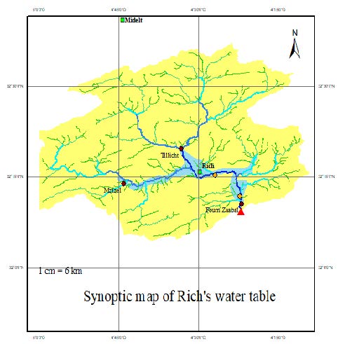
The Basin of Ziz, corresponds to the watersheds of wadis Ziz. This unit is located largely in the province of Errachidia (Agence du Bassin Hydraulique du Guir-Ziz-Rhéris. 2011). The aridity of the climate and the low density of the vegetation cover determine the nature of the soils of the Draa-Tafilalet region; thus, most of the soils are not very developed and those developed are rare due to runoff, wind erosion and salinization, which are mostly located in the province of Errachidia. In its general configuration, the Country of Ziz extends in the meridian direction over 220 km, from jbel Ayyachi (3751 m) in the North to the front of the Hamada of Kem Kem, in the South (850 m), perpendicular to the structural lines of the Eastern High Atlas and the Eastern Anti-Atlas (Tafila et al., 2022). True ethnic crossroads, the Land of Ziz served as a link between the Sahara and the rest of Morocco, on the one hand, and between the various regions of the Moroccan Pre-Sahara. Figure 1. Boundary of the Ziz watershed (El Kayssi et al., 2016).
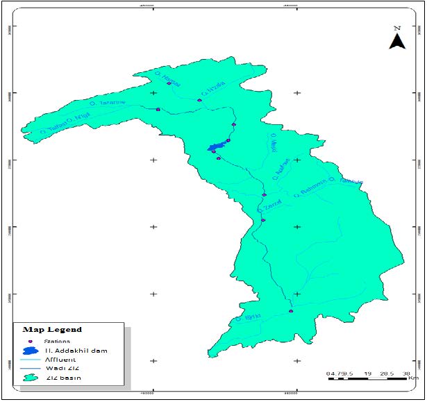
Figure 1: Map of the Ziz Basin hydrographic network
The mean annual temperatures are relatively high. They increase from Foum Zaâbel in the North to Taouz in the South and are respectively around 18.2°C and 22.5°C. Temperatures show very important seasonal variations with a very hot summer and a very cold winter. The latter has low daytime temperatures while nighttime temperatures rarely fall below 0°C (Ait Addi, 1998).
The climatological Moreover, the distribution of stations is very irregular, the majority being concentrated in the High Atlas, while the South East and South West sectors are very devoid.
The rainfall decreases from 260 mm (station Z. Sidi Hamza) in the highlands to 123 mm in the foothills (Hassan Addakhil Dam). In the South, rainfall is about 65.66 mm (Station Radier Erfoud). This low rainfall in the South is due on the one hand to the fact that the Atlas chain prevents any oceanic influence and on the other hand, to the presence of hot air masses from the Sahara (Addi, 2000). The monthly rainfall is characterized by a rainfall regime very variable from one year to another and reflect the irregularity of rainfall. The interannual rainfall modulus increases from the south to the north. It is 65.66 mm at the station Radier Erfoud and reaches 259.33 mm in Zaouiat Sidi Hamza. The annual rainfall pattern is characterized by two wet seasons of autumn and spring separated by a short winter season with a low relative minimum, and by a long summer season very marked by drought (Alahuhta et al., 2018).
2.2 Data Collection and Processing
In order to conduct a complete and reliable study, the quality of the data collection and the degree of certainty of the latter, constitutes the essential and determining phase. These data generally come from the meteorological services, the management of hydraulic basins and the ministerial sector responsible for water. Nevertheless, several laboratory experiments were required to determine the hydrogeological parameters of local soils: such as permeability, texture and water quality (heavy metals, minerals) (Bouwer, 2002). Interpolation methods to estimate missing data and increase the precision of the model developed are used with great frequency, in particular ordinary kriging (Querner, 2000).
All the data collected at the level of the various organizations, in the field and on the Internet, allowed us to establish a GIS database. The latter is one of the platforms most used, which is GIS ArcGIS version 10.3. This software offers many potentialities for the manipulation, management, analysis and editing of spatial data.
Cartographic objects are presented in the geographic information system in the form of layers, each representing a given theme. We can distinguish three types of objects: points, lines and polygons. Several themes are translated into information layers and are transferred and imported into the GIS. All information layers used by the GIS are in shp format.
The data relating to the aforementioned parameters concerning the underground water tables of the perimeter of the Hydraulic Basin of Ziz were collected and processed according to the weighting adopted and based on a notation proportional to the extreme values. The calculation results of evapotranspiration and average monthly precipitation were distributed by interpolation over the geospatial domain concerned. Three phreatic aquifers make up the deeper Ziz basin, with renewable reserves estimated at 482.46 Mm3/year.
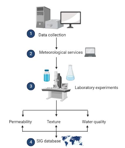
Figure 2: Representative diagram illustrating the data processing sequence
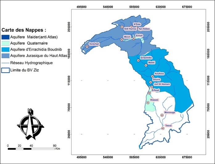
Figure 3: Map of the water table
2.2.1 Stages of Development of The Multi-Criteria Model
The development of the aquifer characterization methodology consists of identifying the most relevant parameters for natural and artificial groundwater recharge and assigning them a representative weight. Here are the identified parameters
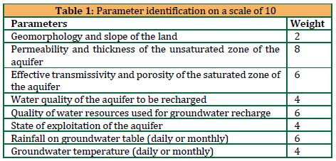
The parameters identified are scored on the basis of a scale of 10; the superposition of the geospatial distributions of the scores assigned to these parameters makes it possible to obtain a special distribution of the values which explicitly translates the aptitude of the studied aquifer to artificial and natural recharge and therefore helps in making the decision on the choice of opportune points for setting up a recharging project.
The methodology developed for the development of this characterization is called: RAN-S2O; in this updating work, the weightings were adjusted and the parameters concerning rainfall and evapotranspiration were added given their significant involvement in water movements between the underground domain and its complement (Murray, 2020).
2.3 Parameter Analysis
The center of Rich and its surrounding localities benefit from the existence of an alluvial aquifer accessible to users at relatively low depths, it depends on the superficial flows of the Ziz wadi and Sidi Hamza having an irregular hydrological regime which depends on rainfall often short and violent. Despite the succession of sometimes long periods of drought and increasingly high-water needs, the level of the water table is kept relatively in balance.
In this context, a hydrogeological characterization and hydrodynamic modeling are necessary for the understanding of the hydrodynamics and the different terms of the balance of this aquifer and this in order to know to what extent the water potential of this aquifer allows a sustained development. sector and respond to the strategy of sustainable management of water resources in the region.
The Er-Rich aquifer extends over 110 km2 and belongs to the southern flank of the central High Atlas on a wide longitudinal depression where the Quaternary alluvium represents the main reservoir facies (Agence du Bassin Hydraulique du Guir-Ziz-Rhéris. 2011). Which are established on the Toarcian-Aalenian marls (Addi, 2000). It is surrounded by a set of anticlinal ridges, which are crossed by the Ziz wadi and the Sidi Hamza wadi, respectively forming the locks of M’Zizel and Tillicht. This aquifer is fed by rainwater and flooding from rivers its discharge is done by underground drainage and pumping (Addi, 2000).
2.3.1 Geomorphology and Slope of The Land
The geomorphology and slopes of the terrain constituting the superficial part of the studied basin is obtained from the digital terrain model:
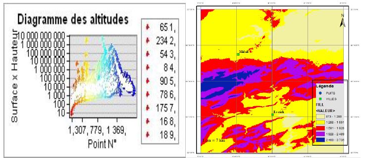
Figure 5: Digital terrain model
2.3.2 Permeability and Thickness of The Unsaturated Zone of The Aquifer
The permeability of soils characterizes their ability to make water flow under a difference of load, it depends in particular on the grain size in the case of alluvial soil, in our case the soil is characterized by an almost total homogeneity, and according to the experiment carried out at the LBCR laboratory on 3 samples at Oued Ziz, based on the darcy method with standardized instrumentation, an average value of: 2.10-4 m/s was retained
The thickness of the unsaturated zone of the Rich aquifer was provided by the ABH of Ziz, it varies between 4 and 45m.
The Ziz basin, and particularly the outcropping part of the errich aquifer, is characterized by a duality of morphology, with on the one hand, the part attached to the southern flank of the High Atlas known by its aggressive slopes and, on the other hand, other leaves the part on the city of Errich in which the values of the slopes of the ground drop and the morphology takes along the main watercourse, the forms of the valleys.
2.3.2 Effective Transmissivity and Porosity of The Saturated Zone of The Aquifer
The groundwater regime has been monitored for 8 years, thanks to the monthly observation of a network of control wells and piezometers. The annual regime of piezometric fluctuations seems quite regular (following figures); the annual amplitudes vary between 0.5 and 1.5m and increase as they approach the fronts of the water table (2 to 3.5m per year).
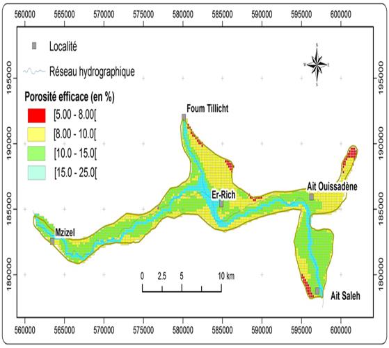
Figure 6: The annual regime of piezometric fluctuations
2.3.4 Quality of the Water in The Aquifer To Be Recharged and Quality of The Water Resources Used To Recharge The Aquifer
Based on the simplified grid for the evaluation of the overall quality of surface water of the joint order of the Minister of Equipment and the Minister responsible for land development, urban planning, housing and environment No. 1275-01 of 10 Sha’ban 1423 (October 17, 2002) defining the quality grid of surface water. The parameters of this grid are those relating to indicators of physico-chemical, microbiological and bacterial pollution. The results of analysis are presented below:

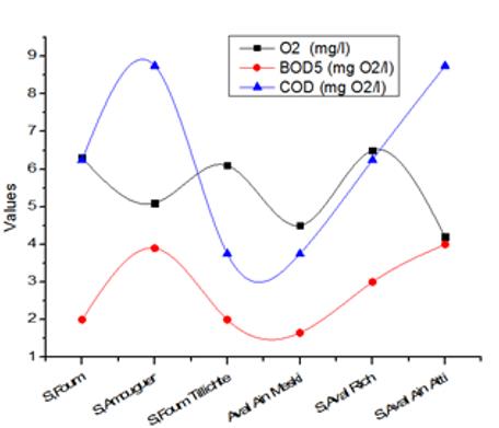
Figure 7: The results of analysis
A general score of 10 was assigned to all points in the water table zone since the variability of water quality in space is relatively low.
2.3.5 State of Exploitation of The Water Table
The Rich aquifer is generally exploited by the drinking water supply of rural communities through pumping in wells, a minimal part is used for irrigation.
According to the monitoring of the piezometric level of the aquifer following ten years of operation, it turns out that the aquifer easily resumes its initial level through its recharge by Oued Ziz, the level remains relatively stable over the years, nevertheless, a remarkable continuous downward trend is recorded at well No. 511/39.
An overall score of 10 was assigned to all points in the water table area since it is one and the same aquifer.
2.3.6 Rainfall on the Ground of The Aquifer (Daily or Monthly)
The land housing the Rich aquifer records especially quasi-regular precipitation delimited by the three-monthly rainfall measurement stations, the following table shows the evolution of precipitation for ten years. The interpolation between the 3 measurement points makes it possible to estimate the average monthly precipitation at any point of the water table.
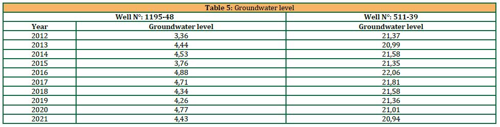
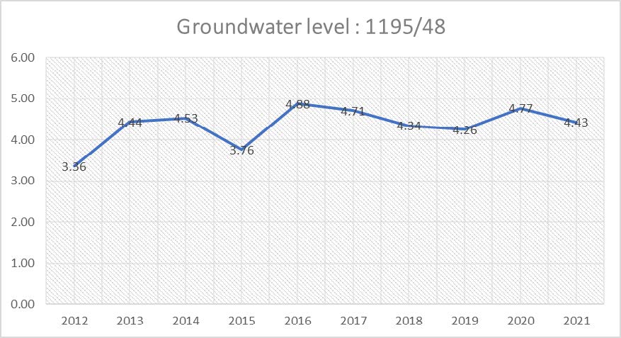
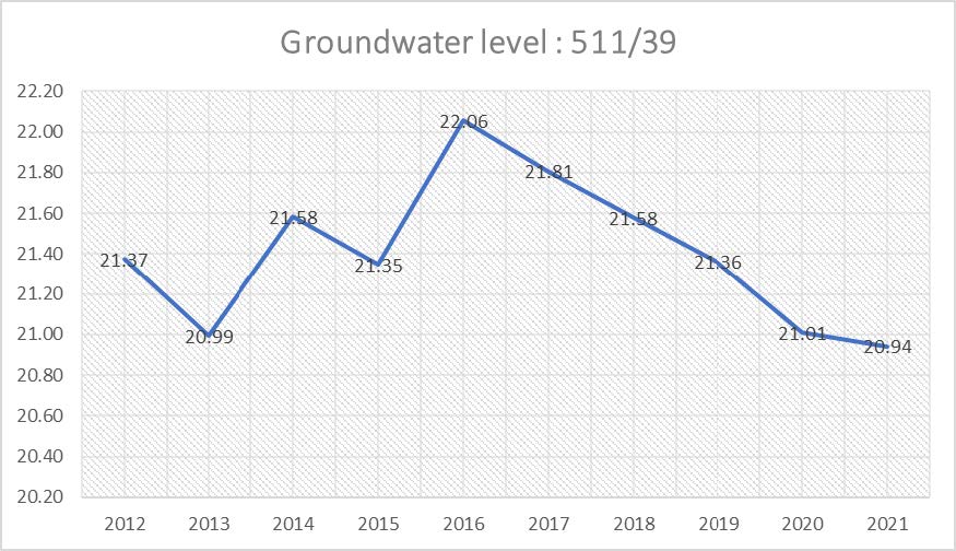
Figure 8: The monitoring of the piezometric level of the aquifer
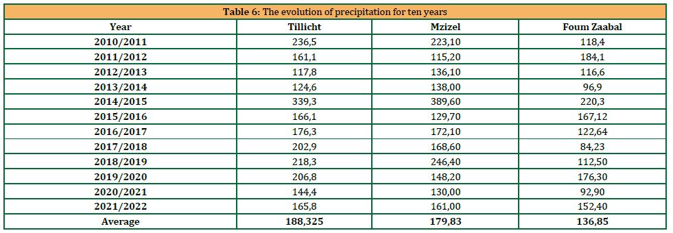
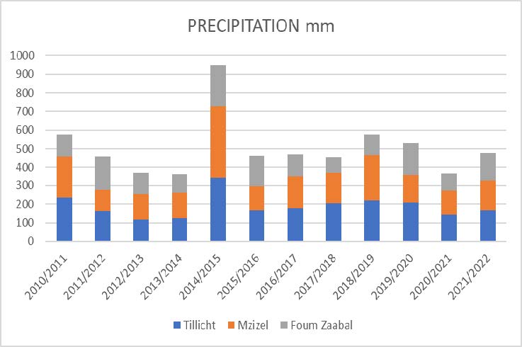
Figure 9: The map of the distribution of precipitation in the Rich’s Nape
The following map shows the distribution of precipitation over the Rich’s Nape domain using the inverse distance formula; we can see that the monthly average of the precipitation is more important by going towards the amons of the Wadi in the most important altitudes.
The circle having as center: the station of Tillicht probably constitutes the most important zone for the natural recharge of the water table, nevertheless, the great slope of the land in this zone favors the opposite hypothesis.
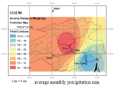
Figure 10: Inverse Distance weighting Prediction Map
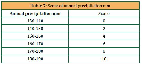
The Score to be given to each point of the terrain with respect to this criterion depends on the minimum and maximum value of the precipitation and will be proportional to each range of values:
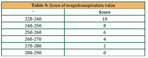
2.3.7 Monthly Evapotranspiration on Groundwater
The plain of Tafilalet (figure 1) is located in the south-east of Morocco, between 4°11 and 4°24 W and 31°00 and 31°42 N. It is crossed by two wadis: Ziz and Rhéris. It is an arid region where rainfall is very low. This is mainly due on the one hand to the fact that the Atlas chain prevents any oceanic influence, and on the other hand to the flow of hot air masses coming from the Sahara (Mina, 1991). In 1958, Margat underlined the importance of evapotranspiration in the region and gave it the following climatic characteristics: Average precipitation, 50-100 mm/year; evapotranspiration, 2000-4000 mm/year; Thornthwaite Aridity Index, -50 to –60; L. Emberger aridity index, 5; Average number of rainy days per year, 10 to 15. Vegetation is very rare in the area apart from the palm groves located around the water points. The population is concentrated mainly in the oases. Agriculture is based on the association of two plant strata: arboriculture with the date palm on the one hand, cereal growing, market gardening and fodder plants on the other. In the palm groves lives a large livestock consisting of cattle, sheep, goats. According to the official census of 1994, the population of the region amounts to 574,425 inhabitants, with an average annual growth rate of 1.81%. More than 61% of the active population practices agriculture.
The three measuring stations at the end of two wings of the Errich sheet are equipped with pots for measuring potential evapotranspiration
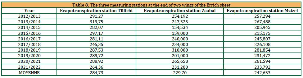
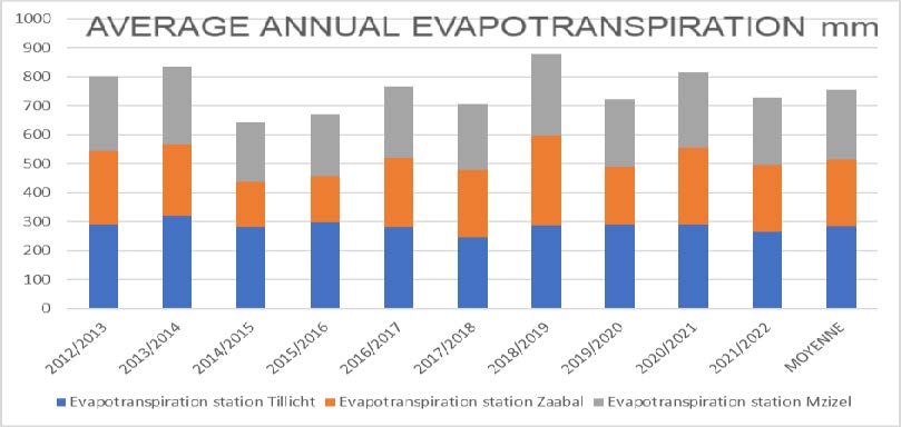
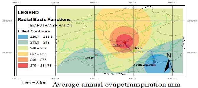
Figure 11: Average annual evapotranspiration mm
3. RESULTS AND DISCUSSION
The overall calculation and measurement of the parameters involved in the weighted equation of the groundwater characterization model for artificial recharge, as well as the assignment of scores to each range of values relative to the amplitudes of the parameters in question, enabled us to conclude a spatial superposition of the total scores for each surface element of the terrain studied. This operation was facilitated by the use of GIS, which enabled us to obtain a characteristic magnitude as a function of space, translating the capacity of the water table for artificial recharge.
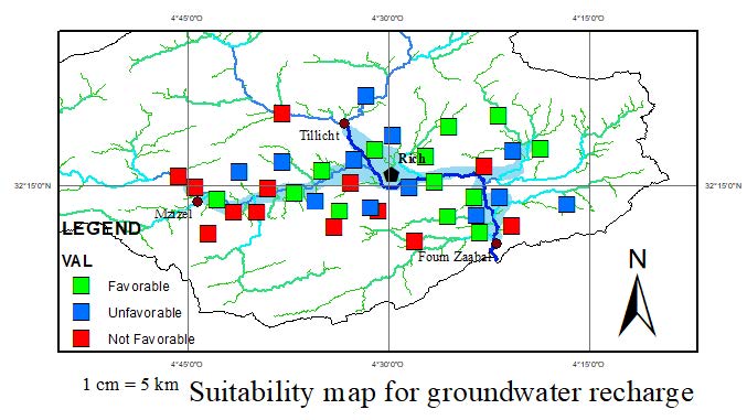
Figure 12: Suitability map for groundwater recharge
The following map shows the potential areas for the implementation of recharge projects according to level of viability: Favorable, unfavorable and not favorable:
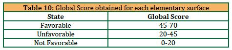
This division is based on the overall score obtained for each elementary surface according to the following thresholds:
According to the groundwater suitability map for artificial recharge drawn up in the course of this research work, it was found that:
-
- Overall, the right part of the aquifer is more favorable to artificial recharge.
- The surroundings of the city of Rich at a distance of 5 km, is potentially interesting for carrying out a groundwater recharge project
4. CONCLUSION
The elaborated model made it possible to have a functional idea on the relevant choice of the site to be considered to carry out a project of recharging the water table of Rich; the noticeable drop in the level of the groundwater obliges us to anticipate future plans to be programmed to stop or reverse the direction of this trend, the artificial recharge of the groundwater proves to be a sustainable and economical solution. In this sense we will be able to see the usefulness of this elaborated model; especially in the decision phase.
REFERENCES
-
- Addi, A. A. 1998. Nouvelles données sédimentologiques et géodynamiques sur les faciès de l’Aalénien-Bajocien inférieur du Haut Atlas marocain (Nord d’Errachidia). Comptes Rendus de l’Académie des Sciences-Series IIA-Earth and Planetary Science, 326 (3), Pp. 193-200. doi : 10.1016/S1251-8050(00)89035-7.
- Addi, A.A., 2000. Les séries du Dogger moyen du Haut Adas au Nord d’Errachidia (Maroc): lithostratigraphie et sédimentologie d’une nouvelle formation: la formation Tazigzaout, Géologie Méditerranéenne, 27 (1), Pp. 57‑69. doi: 10.3406/geolm.2000.1667.
- Agence du Bassin Hydraulique du Guir-Ziz-Rhéris. 2011. Actualisation du plan directeur d’aménagement intégré des ressources en eau des bassins de Guir – Ghris – Recherche Google ». https://www.google.com/search?q=%E2%80%A2+Agence+du+Bassin+Hydraulique+du+Guir-Ziz-Rh%C3%A9ris.+2011.+Actualisation+du+plan+directeur+d%27am%C3%A9nagement+int%C3%A9gr%C3%A9+des+ressources+en+eau+des+bassins+de+Guir+%E2%80%93+Ghris&oq=%E2%80%A2%09Agence+du+Bassin+Hydraulique+du+Guir-Ziz-Rh%C3%A9ris.+2011.+Actualisation+du+plan+directeur+d%27am%C3%A9nagement+int%C3%A9gr%C3%A9+des+ressources+en+eau+des+bassins+de+Guir+%E2%80%93+Ghris+&aqs=chrome..69i57.875861874j0j15&sourceid=chrome&ie=UTF-8 (consulté le 1 juillet 2023).
- Alahuhta, J., Erős, T., Kärnä, O.M., Soininen, J., Wang, J., and Heino, J., 2019. Understanding environmental change through the lens of trait-based, functional, and phylogenetic biodiversity in freshwater ecosystems », Environmental Reviews, 27 (2), Pp. 263‑273. juin 2019, doi: 10.1139/er-2018-0071.
- Bouhlassa, S., and Paré, S., 2006. Évapotranspiration de référence dans la région aride de Tafilalet au sud-est du Maroc. African journal of Environmental assessment and management, 11, Pp. 1‑16.
- Bouwer, H., 2002. Artificial recharge of groundwater: hydrogeology and engineering, Hydrogeology Journal., 10, Pp. 121‑142.
- Daher, W., 2011. Etude de faisabilité de recharge artificielle dans un aquifère karstique côtier, These de doctorat, Montpellier 2. Consulté le: 1 juillet 2023. [En ligne]. Disponible sur: https://www.theses.fr/2011MON20226
- Deschamps, P., Séraphin, P., Khabouchi, I., Gonçalvès, J., Stieglitz, T., Michelot, J.L., and Hamelin, B. 2022. Bilan hydrologique d’un système aquifère surexploité en région désertique: estimation de la recharge et paléorecharge par couplage d’approches satellitaires et géochimiques, in Climat et Impacts.
- Detay, M., 1995. Rational groundwater reservoir management, the role of artificial recharge, Artificial recharge of groundwater. Elsevier, Pp. 231‑240.
- El Kayssi, Y., Hilali, M., and Kacimi, I., 2016. Modélisation hydrodynamique de la nappe alluviale de Rich (Haut Atlas central, Maroc) [Hydrodynamic modeling of the Rich alluvial aquifer (Central high atlas, Morocco)]. International Journal of Innovation and Applied Studies, 14 (3), Pp. 758. https://www.proquest.com/openview/40c7420af3ada92d2e0dac18e41a8a4c/1?pq-origsite=gscholar&cbl=2031961 (consulté le 1 juillet 2023).
- Eusuff, M.M., and Lansey, K.E., 2004. Optimal operation of artificial groundwater recharge systems considering water quality transformations. Water resources management, 18, Pp. 379-405.
- GAALOUL, N., 2015. Modélisation des écoulements souterrains en milieu poreux non sature: application à la recharge artificielle par les eaux usées traitées nappe côtière Korba (Cap-Bon Tunisie). LARHYSS Journal P-ISSN 1112-3680/E-ISSN 2521-9782, (21), Pp. 171-180.
- IMAZOUMOU, Y., and Besbes, M., 2000. Simulation de la recharge artificielle de nappe en oued par un modèle à réservoirs. Revue des sciences de l’eau/Journal of Water Science, 13 (4), Pp. 379-404.
- Jódar-Abellán A., Albaladejo-García J. A., and Prats D., 2017. Artificial groundwater recharge. Review of the current knowledge of the technique.
- Khomri, Z., 2014. La Recharge Artificielle De La Nappe Alluviale D’oued Biskra.
- Lal, A., and Datta, B., 2018. Modelling saltwater intrusion processes and development of a multi-objective strategy for management of coastal aquifers utilizing planned artificial freshwater recharge. Modeling Earth Systems and Environment, 4, Pp. 111-126.
- Murillo Diaz, J. M., and Lopez Geta, J.A., 2000 « Artificial recharge of aquifers in zones with irregular precipitation and high land values », Hydrogéologie Orléans, no 3, p. 3‑12, 2000.
- Murray., A.J., 2020. Modeling Artificial Groundwater Recharge in the Santa Rosa Creek Watershed.,
- Pinault, J. L., Plagnes, V., Aquilina, L., and Bakalowicz, M., 2001. Inverse modeling of the hydrological and the hydrochemical behavior of hydrosystems: characterization of karst system functioning, Water Resour. Res., 37 (8), Pp. 2191‑2204.
- Pyne, R.D.G., 2005. Aquifer storage recovery: a guide to groundwater recharge through wells.
- Querner, E.P., 2000. The effects of human intervention in the water regime, Groundwater, 38 (2), Pp. 167‑171.
- Remini, B., Achour, B., Amara, L., Mballo, I., Sy, O., Thior, M., and Sintondji, L.O., 2019. L’oasis d’El Guerrara (Algérie), irrigation et recharge des nappes assurées par les inondations, Larhyss Journal., 40, Pp. 213‑247.
- Rezaei, F., and Safavi, H.R., 2020. f-MOPSO/Div: an improved extreme-point-based multi-objective PSO algorithm applied to a socio-economic-environmental conjunctive water use problem, Environmental Monitoring and Assessment., 192, Pp. 1‑27.
- Shafa, N. S., Babazadeh, H., Aghayari, F., and Saremi, A., 2023. Multi-objective planning for optimal exploitation of surface and groundwater resources through development of an optimized cropping pattern and artificial recharge system. Ain Shams Engineering Journal, 14 (2), Pp. 101847.
- Stefan C. and Ansems, N., 2018. Web-based global inventory of managed aquifer recharge applications, Sustain. Water Resour. Manag., 4 (2), Pp. 153‑162.
- Tafila, O., Ranganai, R.T., Moalafhi, D.B., Moreri, K.K., and Maphanyane, J.G., 2022. Investigating groundwater recharge potential of Notwane catchment in Botswana using geophysical and geospatial tools, Journal of Hydrology: Regional Studies, 40, Pp. 101011.
- Voisin, J., 2017. Influence des pratiques de recharge des aquifères par des eaux pluviales sur les communautés microbiennes des nappes phréatiques. Université de Ly
| Pages | 380-388 |
| Year | 2024 |
| Issue | 3 |
| Volume | 8 |
